Morocco earthquake: Why it happened, and how to prepare in future

Morocco isn’t necessarily the first country that comes to mind when one thinks of frequent earthquakes.
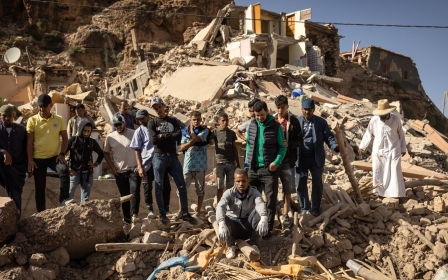
Quakes of the scale of Friday’s disaster - which was 6.8 in magnitude and has killed at least 2,862 people - are rare but not unheard of in the North African country.
Unlike countries such as Turkey and Syria, which have a high propensity for quakes due to their location at a crossroads of the Earth's tectonic plates, only a small area of northern Morocco lies at the intersection of plates.
But it has been impacted by seismic activity on several occasions over the past quarter of a millennium, including a 15-second tremor that buried the major city of Agadir in 1960.
Friday’s earthquake was caused by a collision between the African and Eurasian plates.
New MEE newsletter: Jerusalem Dispatch
Sign up to get the latest insights and analysis on Israel-Palestine, alongside Turkey Unpacked and other MEE newsletters
“The collision of Africa and Eurasia is a major tectonic event that started some 60 million years ago, closing a large oceanic basin called the Thesis,” Sylvain Barbot, associate professor of earth sciences at the University of Southern California, explained to Middle East Eye.
Plate boundaries and fault lines
Although the epicentre of the earthquake was 550km south of where the plates bump against each other, the region is still an at-risk area.
“The remnants of the Thesis Sea is the Mediterranean basin today. The closure of the Thesis formed the French Alps, the Zagros Mountains and the Himalayas,” said Barbot.
He added that Morocco’s High Atlas mountains contribute to the plate convergence, hosting occasional quakes.
'If the faults are mapped it is possible to improve earthquake forecasts'
- Jonathan Stewart, engineering professor, UCLA
“The reason why the earthquake occurred far away from the plate boundary is because the Atlas Mountains is a local weakness in the [Earth’s] crust.”
In the case of the 2004 earthquake which struck Al-Hoceima on Morocco’s northern coast, the tremors did occur on the plate boundary. It is the most seismically active area in the country.
That quake killed 630 people and displaced 15,000 others.
Several other major quakes in Morocco have occurred away from the boundary, including the 1960 disaster in Agadir.
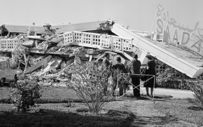
The 5.8-magnitude tremor buried the entire city and killed around 15,000 people, over a third of Agadir’s population. The city was completely rebuilt one mile south of the previous metropolis.
“Earthquakes are possible everywhere, but their relative likelihood is much higher in regions of crustal deformations [e.g. mountains] and faulting,” Jonathan Stewart, a professor of civil and environmental engineering who specialises in earthquake engineering at the UCLA Samueli School of Engineering, told MEE.
Fault lines are fractures in the Earth’s surface, often caused by the movement of tectonic plates. They are responsible for many earthquakes.
“There are stresses in plates away from plate boundaries. Usually they are concentrated along faults,” Stewart explained. “So if the faults are mapped it is possible to improve earthquake forecasts.”
Mudbrick and masonry buildings
Proximity to plate boundaries often has a large effect on the preparedness of countries for earthquakes.
Stewart said that places like Japan, Taiwan and California, where there are high rates of seismicity along plate boundaries, have advanced levels of preparedness.
“However, there are also examples of societies along plate boundaries with relatively poor preparedness (e.g. poor building codes, or poor implementation of building codes), such as Nepal, Pakistan and Turkey.”
Stewart added that in areas away from boundaries, attention levels on seismic resilience tend to be “limited”.
'The Marrakech earthquake shook many historic buildings that are not designed to withstand such large shaking'
- Sylvain Barbot, Earth sciences professor
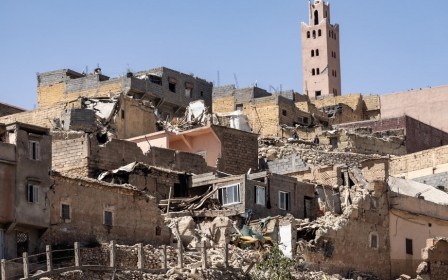
In the case of Morocco, several of the structures that were destroyed were mudbrick houses and masonry buildings.
“The Marrakech earthquake shook many historic buildings, otherwise known as pre-code buildings, that are not designed to withstand such large shaking,” said Barbot.
He explained that resistance to such shaking depends on both the strength of the foundations and the frame of the buildings - with taller structures more prone to damage.
“Mudbrick and masonry building [collapse] under what we call brittle failure, which make such buildings prone to sudden collapse.
“Steel reinforced buildings undergo ductile failure, which can be damaged, but avoids complete collapse of the structure.”
Several medieval buildings, which attract significant tourism to Morocco, were damaged by the quake, including the Tinmel Mosque in the High Atlas mountains and Marrakech's Old City and ancient walls.
Stewart noted that such historic buildings can incorporate seismic isolation systems, such as was the case for San Francisco’s City Hall, though such measures can be costly.
As well as the building material, the timing of this earthquake - at night - will also have contributed to impact on human life.
“Earthquakes that happen at night can aggravate the casualties because people may be more at risk in their own dwellings if there are building collapse,” said Barbot.
In addition, the darkness of the night can make it difficult for survivors to navigate debris and rubble when attempting to reach safety, increasing risk of injury.
Future planning
There are several steps Moroccan authorities can take in the future to attempt to avoid the levels of destruction seen in recent days.
For Stewart, mapping and modelling is key to improving earthquake resilience.
“Map earthquake faults. Develop regionally appropriate models for predicting earthquake ground motions,” he said.
“Produce seismic hazard maps that reflect the product of these models and integrate such maps into the seismic design process.”
The other area to address to enhance preparedness is the structure of buildings.
Authorities should “update building codes to reflect modern knowledge and practices [and] enforce building codes”, Stewart said.
He added that incentives need to be developed to ensure that older structures are retrofitted.
This article is available in French on Middle East Eye French edition.
Middle East Eye delivers independent and unrivalled coverage and analysis of the Middle East, North Africa and beyond. To learn more about republishing this content and the associated fees, please fill out this form. More about MEE can be found here.