Syria: 'Potentially devastating' oil spill heading for Turkish coastline

An oil spill off the coast of Syria now heading towards the shores of Turkey is set to have disastrous consequences, with effects likely to be felt for at least 15 years, environmental groups said on Wednesday.
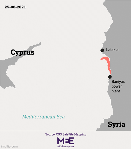
Early last week, on 23 August, a fuel tank containing roughly 12,000 cubic metres of fuel at Syria's depleted Baniyas thermal power plant began to leak into the Mediterranean.
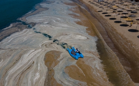
Satellite images show how the oil slick then spread from Syria's western coast towards Cyprus. It now appears to be threatening Turkish shorelines to the north, covering an estimated 800-1,000 square kilometres of water.
The World Wide Fund for Nature (WWF) warned of "potentially devastating consequences for marine biodiversity and ecosystems" on Wednesday, adding that the spill "poses serious risks also for the communities and businesses that depend on tourism and marine resources for their livelihoods".
Environmental experts speaking to Middle East Eye said water quality, marine and coastal flora and fauna - "from plankton to dolphins and fish for consumption" - and coastal communities would all likely be affected.
A team off the coast of Cyprus was filmed lifting a dead turtle - covered in oil - out of the sea on Wednesday.
To make matters worse, said Mauro Randone, coordinator of the Sustainable Blue Economy Programme at the WWF Mediterranean Marine Initiative, the Mediterranean being a "semi-enclosed basin" means "the oil stays in there, it's very difficult to get the natural dispersion that you can have in other parts of the world."
The effects of the spill will be felt for more than a decade, he added. "The minimum is 15 years, and then you go upwards from there.
"[The oil] is staying in there for the long term, and that's what really worries us."
'The solution is to avoid spills'
Natasa Ioannou, a marine biologist at Friends of the Earth Cyprus, told MEE it would likely take at least three months for environmentalists to have any idea of the true scale of the spill's impact.
This will depend on the efficiency of the clean-up operation and where the wind and currents push the slick.
A rocky shore, for example, is "very, very difficult" to rid of oil, said Randone, adding: "The solution is to avoid oil spills, not to clean then up afterwards."
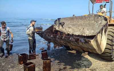
Nearly half of the oil mass has ended up on the Syrian shoreline, according to the Regional Marine Pollution Emergency Response Centre for the Mediterranean Sea (REMPEC).
Syria's state news agency (SANA) reported on Monday that much of the fuel had ended up along the coast at Baniyas and Jableh, 20km (12 miles) north of the refinery.
Local media also posted images of workers cleaning the shore with shovels, metal cans and a digger.
Israel said last week that the spill had not spread to its shores.
In February, a separate spill hit 160km (100 miles) of coastline in Israel, Gaza and Lebanon, a disaster that officials said could take years to clean up.
The Mediterranean has seen comparatively few oil spills in recent years, according to a 2017 report from REMPEC. The largest came in 1991, when an oil tanker named the MT Haven sank after an onboard explosion, releasing 144,000 tonnes of crude oil into the sea near Genova, Italy.
In 1985, the BP Vision spilled 15 tonnes of crude at the Baniyas terminal.
'Anything can happen'
The satellite imagery experts use to track oil spills is not fully comprehensive. Heavy oils, such as the type involved in this spill, spread into smaller, "discrete patches or streaks", according to a US Department of Commerce report, making it hard to accurately track the spread, and there are a host of natural phenomena - including kelp beds and reflections from the water - that can confuse analysis.
But "there's no other way," Juan Peña, CEO of Orbital EOS, an organisation that has been tracking the slick, told MEE.
"You need to observe this from space," he said. "You don't have the capability to understand a 1,000-km oil spill from a plane like we used to do in the past."
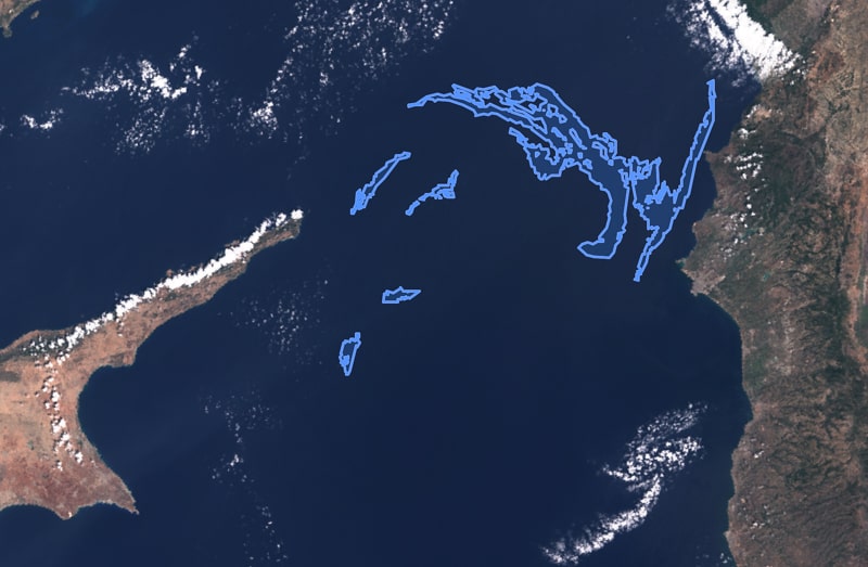
Forecasts had predicted oil would reach beaches in northern Cyprus, but weather conditions seem to be pushing the oil towards the coastlines of Turkey, which has sent two ships out to help control and collect some of the oil, according to AFP.
A satellite image from the European Space Agency taken at 09:03 London time on Wednesday and provided - with markings in blue - by Orbital EOS to MEE appeared to show the oil slick, covering roughly 910 square km (350 square miles), heading north.
"Nothing has been located in the areas under the control of the Republic of Cyprus," the country's agriculture minister, Costas Kadis, said on Tuesday.
"But anything can happen in the coming days," Randone told MEE.
The maritime - and possibly land - clean-up operation there may be hampered by the island’s long-standing hostilities.
The Mediterranean island of Cyprus has been split along ethnic lines since 1974, between an internationally recognised Greek Cypriot government in the south and a breakaway northern region established following a Turkish invasion.
The north was occupied by Turkey in response to a coup that aimed to annex Cyprus to Greece. Since unilaterally declaring independence in 1983, the Turkish Republic of Northern Cyprus, which is financially supported by Turkey, is only recognised by Ankara.
Kadis said on Tuesday that authorities in the Greek Cypriot south were willing to cooperate with counterparts in the Turkish-controlled north.
"Unfortunately," he added, "our intention and willingness to help, so far, remain unanswered, we have not received any information or any response from the authorities of the illegal regime."
A preventable disaster
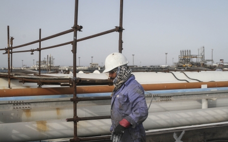
Before 2011, the Baniyas refinery provided 20 percent of Syria's fuel needs and was one of five in the country.
But the decade-long conflict in Syria has led to a "structural collapse" of the county's energy infrastructure, Wim Zwijnenburg, project leader at Pax, a Dutch NGO, told MEE.
Though Syria's two functioning oil refineries, in Baniyas and Homs, remain under the control of Damascus, they have been targeted by attacks in recent years, and the country's oil resources in the east are held by Kurdish-led forces and the US military.
Oil production has plummeted during the fighting, and Syria’s oil pipelines have been hit by armed groups, with Iranian ships delivering oil to Syria, which is under US sanctions and reliant on its eastern neighbour.
In June 2019, an alleged attack on underwater pipelines in Baniyas led to a month-long oil spill.
This January, a huge blaze hit the depot area near Homs station, engulfing a number of oil tankers loading crude oil from an installation.
In April, three people died when an Iranian tanker was attacked off Syria's coast. Syria has blamed Israel for the attack, the first of its kind since Syria's civil war started a decade ago.
Then in May, a second major fire ripped through a significant part of the Homs refinery, following a leak at a pumping station.
Baniyas has also seen a marked increase in oil spills and dumping of oil-contaminated wastewater in recent years, added Zwijnenburg.
So though he wasn’t expecting a slick like this, "it wasn't a big surprise".
"We're probably going to see more spills coming from the ships delivering oil if nothing's fixed," he added. "It will be just waiting for the next incident to happen."
This article is available in French on Middle East Eye French edition.
Middle East Eye delivers independent and unrivalled coverage and analysis of the Middle East, North Africa and beyond. To learn more about republishing this content and the associated fees, please fill out this form. More about MEE can be found here.