Israel-Palestine: Google says it has 'no plans' to update blurry maps of Gaza

Google has said it has no plans to update low-resolution imagery of Israel, the occupied Palestinian territories and the besieged Gaza Strip, despite a US law that banned the use of high-quality images being lifted last year.
Prior to agreeing to a ceasefire early on Friday, Israel bombed Gaza for 11 days, killing at least 248 Palestinians, including 66 children, 39 women and 17 elderly men.
The air strikes damaged schools, power lines, water, sanitation and sewage systems for hundreds of thousands of people in a territory that has been under blockade by Israel and Egypt for more than a decade.
Conflict researchers told Middle East Eye it would be difficult to understand the true damage caused by Israeli air strikes due to many open source mapping tools - including Google, Apple, and Bing - which have failed to update their maps with high-resolution imagery.
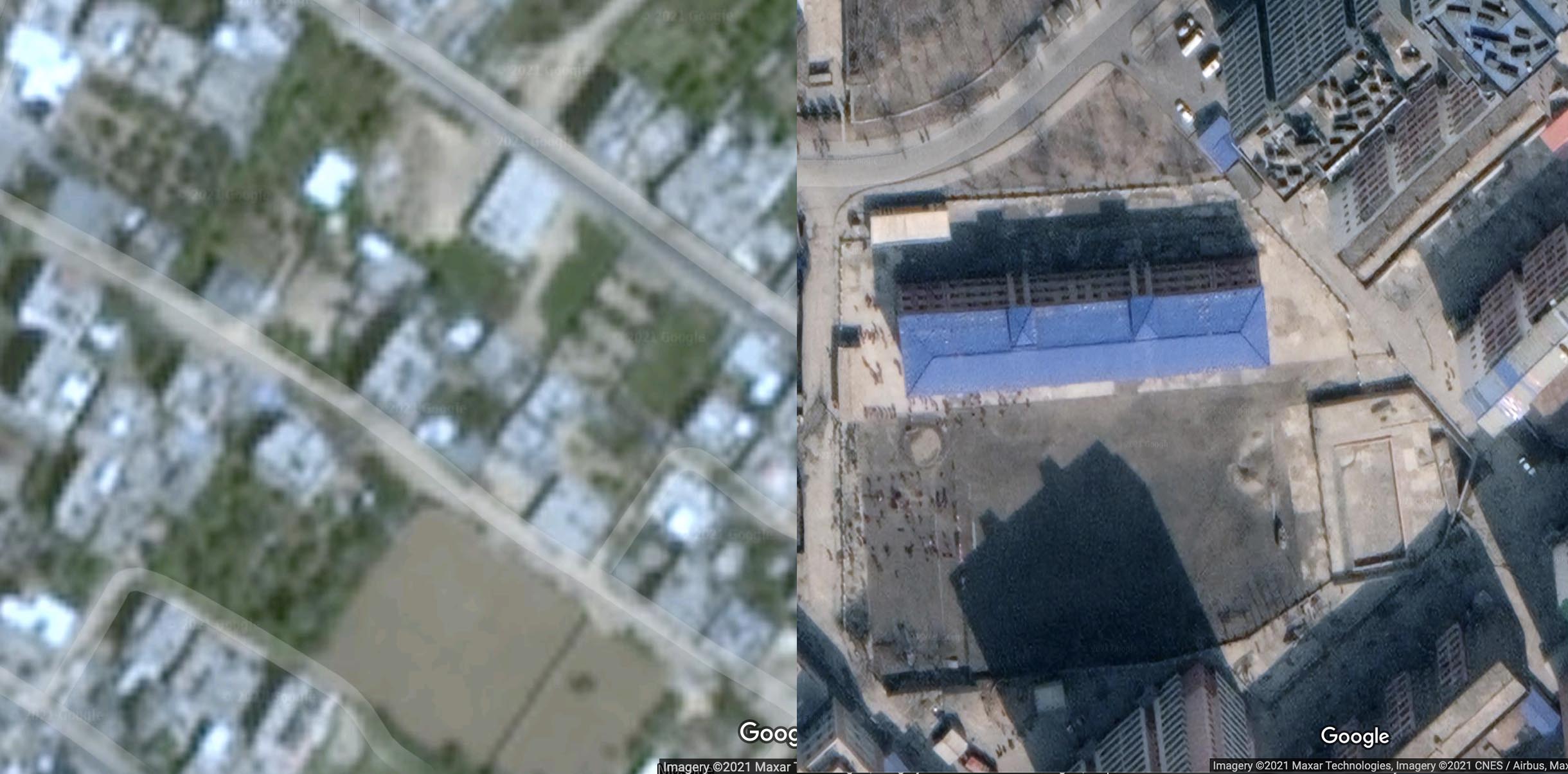
At present, satellite imagery for Gaza is at a resolution of two metres per pixel, meaning buildings and streets show up blurry and are difficult to identify.
New MEE newsletter: Jerusalem Dispatch
Sign up to get the latest insights and analysis on Israel-Palestine, alongside Turkey Unpacked and other MEE newsletters
Aric Toler, who leads training and research efforts for the investigative journalism website Bellingcat, said that in order to verify or analyse a photo or video that shows a destroyed building in Gaza on Google Maps, he would "have to rely on either getting really lucky with the angle / content of a blurry satellite image" or find another way altogether.
"It's very hard to make out objects with the existing imagery on free mapping services," he told MEE.
Other areas around the world, including the secretive North Korean capital Pyongyang, are detailed enough to see people walking on the streets.
Google said that it considers "opportunities to refresh our satellite imagery as higher resolution imagery becomes available", but that it has "no plans to share at this time".
Meanwhile, Apple told BBC that it was working to update its maps soon to a higher resolution. Microsoft, the parent company of Bing, appears to be displaying lower-resolution imagery as well. Microsoft did not respond to MEE's request for comment.
Not surprising
The original reasoning behind the low-resolution satellite imagery of Israel and the occupied Palestinian territories comes from a 1997 amendment to the US national defence authorisation act.
The Kyl-Bingaman Amendment restricted the use of satellite imagery in Israel and Gaza to two metres per pixel, citing security concerns at the time. However, last year the amendment was revised to allow for greater resolution of the area.
According to Google, "satellite imagery in Google Maps and Earth is built from a broad range of providers, including public, government, commercial and private sector sources".
Yet one of those companies, Maxar Technologies - which is shown as a source of its map data for Gaza as of 2021 - offers much higher resolution images than Google utilises.
High-resolution satellite imagery is an important tool for researchers, investigative journalists, and human rights groups to track what is taking place during a conflict.
Such imagery has been used to show the destruction of more than 200 Rohingya villages by the Myanmar military in 2017, as well as to report on a network of "re-education" centres set up for the Uyghurs across the Xinjiang region in China, in addition to the destruction of thousands of mosques there.
Satellite imagery has also been used to expose large prison camps in North Korea that the government had denied existed.
Still, when it comes to the issue of Israeli air strikes on the Gaza Strip, researchers have had to rely on paid satellite imagery, such as Maxar, or find other ways of confirming what buildings or areas were bombed.
Marwa Fatafta, a policy analyst at the Palestinian policy network al-Shabaka, said the decision was not suprising, considering that Google is "lending its cloud service to the Israeli government & their military apparatus".
Earlier this year, Google, alongside Amazon Web Services, was awarded a $1.2bn offer to provide cloud services to Israeli government agencies.
The tech giant has also been accused of violating international law by recognising illegal Israeli settlements in the occupied West Bank, according to the Arab Center for Social Media Advancement, 7amleh.
Middle East Eye delivers independent and unrivalled coverage and analysis of the Middle East, North Africa and beyond. To learn more about republishing this content and the associated fees, please fill out this form. More about MEE can be found here.