Google-Palestine row is symptom of a Middle East mapping minefield


Google sparked an outcry last week after reports emerged that it had allegedly removed Palestine from its maps.
But, as the company responded, Google hadn’t deleted Palestine – it had never actually displayed it as an independent country in the first place.
Nevertheless, a debate had started on whether Google should have put Palestine, which holds non-member UN observer state status, as a separate country on maps as it does with all 193 UN member states.
While some involved in the debate say Palestine should be shown separately from Israel as it is not considered to be part of Israel by a majority of the world's nations, others argue that this would ignore Israel’s occupation of Palestinian territories.
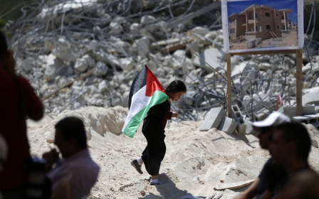
While Palestine - as a majority of countries acknowledged in the 2012 UN observer status vote - does exist, it does not exist as a fully fledged independent state, with clear-cut borders. In reality, Palestine only exists in the dozens of enclaves in the West Bank, which Palestinians were given as a result of the 1993 Oslo Accords, and the Gaza strip.
The major roads in the West Bank, the Jordan Valley and East Jerusalem, while internationally considered to be part of Palestine, are under full Israeli control. Showing these areas as part of Palestine would be politically correct, but not an accurate display of the situation on the ground.
Facts on the ground
The same argument could be made for Crimea: while it is still considered Ukranian territory by the international community, Russian authorities call the shots on the peninsula and have done so since its annexation in 2014. It would be misleading to show Crimea on the map as Ukrainian when it's Moscow that rules the region, not Kiev.
The problem is that in modern times maps are political, but should be realistic
This is the issue with maps nowadays: should mapmakers get involved in politics, and show disputed areas around the globe in the manner in which they're generally recognised by the international community? Or should they stay away from politics altogether and show the situation as it is?
The problem is that in modern times maps are political, but should be realistic. Maps are political in the sense that, by displaying the territory of a separatist state, a terrorist group or a rebel organisation, they are basically giving these parties recognition, taking away the territory from the state which holds claim over it.
But maps are expected to show the reality of today's world and showing separatist areas like, for example, Abkhazia and South Ossetia as part of Georgia, would ignore the reality on the ground. Besides, it would also be a denial of the ongoing conflict - as was the main argument of those who disagreed with Palestine being put on maps.
Enclaves and territories
Take Syria and Iraq for example: both are shown on the map in the way that they are generally recognised by the world - as two countries.
But in reality, Iraq is now split into three territories: the Kurdistan region, lands held by the Islamic State (IS) group and the remainder of Iraq. Syria is even more complicated. One could say the country has disappeared into dozens of small states and enclaves with Syrian rebels, IS, Kurds, the Assad regime, al-Qaeda-affiliated jihadists and Hezbollah all controlling parts of what was once a single country.
Like the walkman and the pager, the old maps that used to hang in the classroom are outdated
Showing IS on the map as a separate state would be very controversial as it would (in a way) legitimise their rule over the areas they occupy and give them recognition as a state. But the fact remains that they do control cities like Raqqa and Mosul and have done so for more than two years now.
The same goes for the Kurds who have been dreaming of seeing the name "Kurdistan" on a map for decades. The Iraqi Kurdish region, with Erbil as its capital, functions as an independent nation in a lot of ways, but no world map shows it as such. Doing so would make a lot of Kurds happy, but would definitely anger Baghdad. 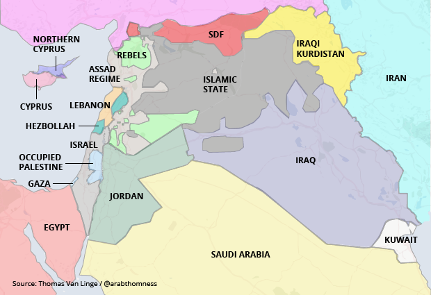
Some choose to show it as separate, and others show it as part of Morocco, which has occupied most of it for decades. Hardly any map shows it as the two separate states it now basically is - with the coastal part under Moroccan occupation, while the eastern desert area is ruled by the "Sahrawi Arab Democratic Republic".
Like the walkman and the pager, the old maps that used to hang in the classroom are outdated. Such maps could still reflect reality in the US or UK, but definitely not for most of the world anymore.
A map of the Middle East, showing all countries organised as they are internationally recognised, would be inaccurate and useless for those who want to understand what is happening on the ground.
As the world is changing so too should the maps that show it. Since the collapse of the USSR, the world has changed a lot, but world maps hardly have. The old maps where every country has one colour, one capital, and one name aren't relevant anymore.
Just like the way we have revolutionised cars, medical care and engineering, so we need to change the maps that show the beautiful world we live in with all of its imperfections.
- Thomas van Linge is a political science student and activist based in Amsterdam. He is mostly known for his maps of war zones in the Middle East. You can follow him on Twitter @arabthomness.
The views expressed in this article belong to the author and do not necessarily reflect the editorial policy of Middle East Eye.
Photo: Google map captured on 15 August 2016 (Google)
This article is available in French on Middle East Eye French edition.
New MEE newsletter: Jerusalem Dispatch
Sign up to get the latest insights and analysis on Israel-Palestine, alongside Turkey Unpacked and other MEE newsletters
Middle East Eye delivers independent and unrivalled coverage and analysis of the Middle East, North Africa and beyond. To learn more about republishing this content and the associated fees, please fill out this form. More about MEE can be found here.