Benjamin Netanyahu and maps: A brief history of an enduring love affair

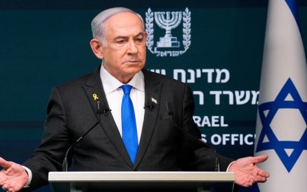
At a news conference on Monday, Israeli Prime Minister Benjamin Netanyahu enraged a broad cross section of the international community by displaying one map that excluded the occupied West Bank and another that showed a separate Western Sahara.
An often flamboyant media performer, Netanyahu likes to use visual aids to convince audiences to see the world the way he sees it.
For over three decades, his preferred prop has been maps, which he likes to gesticulate towards with a trusty pointer. Sometimes, the maps are used to show an expanded Israel; other times, they are used to show an embattled Israel surrounded by many threats, often emanating from Iran.
Netanyahu has displayed maps of the Middle East as envisioned by him, maps of Israel without the Palestinian territories, historic maps where Israel appears much larger, maps of Iran’s alleged secret nuclear sites or its supposed global terror network, maps of planned Israeli settlements and maps that Donald Trump has annotated.
On Monday, his intention was clear: provocation. Over the years, Netanyahu has displayed maps showing Israel stretching from the Jordan River to the Mediterranean Sea, and he did so again.
New MEE newsletter: Jerusalem Dispatch
Sign up to get the latest insights and analysis on Israel-Palestine, alongside Turkey Unpacked and other MEE newsletters
In his geography lesson, he invoked the phrase "from the river to the sea". When used by Palestinians, this phrase stirs great controversy. But for Netanyahu, it presented no issue.
To mark this enduring love affair, here are some of Benjamin Netanyahu’s most notable maps, presented to audiences around the world.
The 90s maps
It is difficult to pinpoint exactly when Netanyahu’s passion for maps began. Perhaps as a young boy growing up in Jerusalem and later in the United States, the future leader sketched the world as he saw it.
What we do know is that as early as May 1990, just after his 40th birthday, Netanyahu was in public, standing before the United Nations, pointing at a map.
During a UN Security Council meeting in Geneva, Netanyahu, then Israel’s deputy foreign minister, showed a map illustrating the various Palestinian groups he claimed were threatening Israel’s existence.
![]()
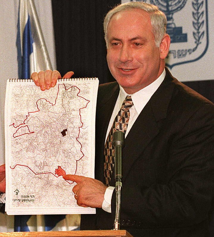
![]() In 1997, Netanyahu can be seen showing the neighbourhood of Har Homa in occupied East Jerusalem, where the green light had been given for the construction of 2,500 homes for Jewish settlers. The area was marked in red and Netanyahu, smiling, was creating facts on the ground, showing people the world he intended to create.
In 1997, Netanyahu can be seen showing the neighbourhood of Har Homa in occupied East Jerusalem, where the green light had been given for the construction of 2,500 homes for Jewish settlers. The area was marked in red and Netanyahu, smiling, was creating facts on the ground, showing people the world he intended to create.
The Iran maps
While Netanyahu frequently uses maps to project strength, it is equally important for him to emphasise perceived threats.
When illustrating his claims about Iran’s malign intentions, he often reaches into the prop cupboard.
In a June 2018 video titled “Could you stop Ronaldo from scoring a goal?!”, the Israeli prime minister is seen catching, playing with and then holding a football as he praises the Iranian football team for saving a penalty from Christiano Ronaldo (and calls on the Iranian people to topple their government).
![]()
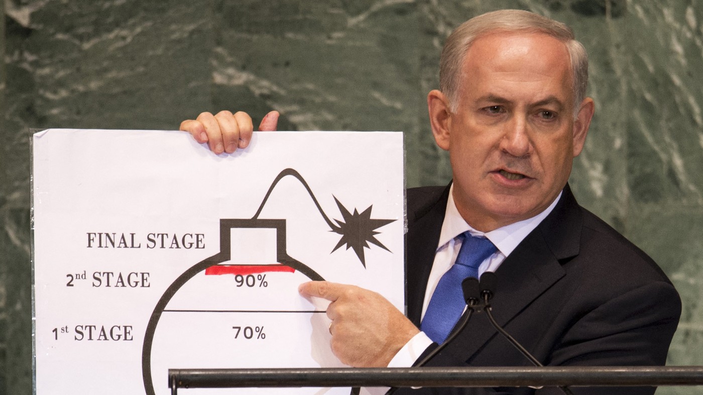
![]() Speaking at the United Nations in 2012, a grave-faced Netanyahu held up a cartoon bomb with a fuse, marking Israel’s “red line” for Iranian uranium enrichment with a red pen.
Speaking at the United Nations in 2012, a grave-faced Netanyahu held up a cartoon bomb with a fuse, marking Israel’s “red line” for Iranian uranium enrichment with a red pen.
At the America-Israel Public Affairs Committee (Aipac) annual conference in 2015, he used a map covered with images of people, explosions, cars and documents to illustrate Iran’s nefarious global influence. His message was clear: they are everywhere and they are out to get us.
Speaking again at the UN General Assembly (UNGA) in September 2018, Netanyahu first brought out a map of “secret atomic warehouses” in Tehran, an “innocent-looking compound” with a rug-cleaning operation just 100m away. “By the way, I hear they do a fantastic job of cleaning rugs there,” he joked.
In front of the UN, Netanyahu then moved on to a “picture that’s worth a thousand missiles”: a map of Beirut airport, where the prime minister claimed - without evidence - that Iran was “directing Hezbollah to build secret sites to convert inaccurate projectiles into precision-guided missiles, missiles that can target deep inside Israel within an accuracy of 10m”.
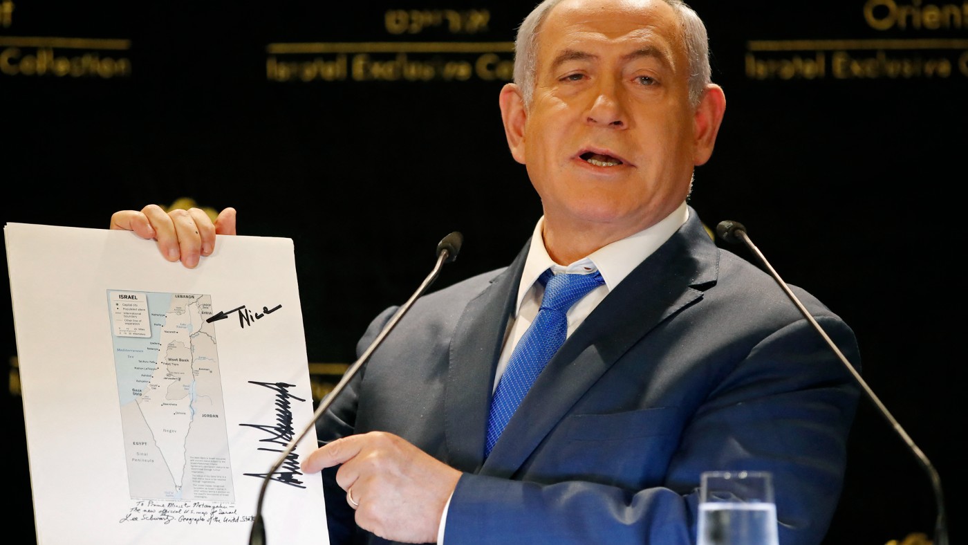
The Donald Trump map
After meeting with then-US President Donald Trump’s son-in-law, Jared Kushner, in May 2019, Netanyahu proudly brandished a map Kushner gave him on behalf of his boss.
![]()
![]() The map of Israel was signed by Trump, a great ally of Netanyahu, who had drawn an arrow pointing at the disputed Golan Heights with the word “Nice” scrawled in the margins.
The map of Israel was signed by Trump, a great ally of Netanyahu, who had drawn an arrow pointing at the disputed Golan Heights with the word “Nice” scrawled in the margins.
The Golan Heights, a raised plateau in southwestern Syria, was unilaterally annexed by Israel in 1981, a move never recognised internationally. But in March 2019, Trump’s administration unilaterally recognised the annexation.
The 'New Middle East' map
We return to a setting beloved by Netanyahu and his maps: the UNGA. In September 2023, the Israeli prime minister presented a map titled “The New Middle East”, which seemed to erase Palestine by incorporating the West Bank and Gaza as part of Israel.
Earlier in the same speech, Netanyahu also showed a map of Israel from 1948 that included the Palestinian territories within the newly formed state.
Contrary to his maps, Israel did not control the West Bank, including East Jerusalem, or Gaza after its creation in 1948 on 80 percent of historic Palestine. These areas were occupied by Israel in 1967 and remain under Israeli control.
Netanyahu used his “new Middle East” map to promote the reshaping of the region based on establishing ties with Arab countries, particularly Saudi Arabia.
The map showed the audience what Netanyahu was telling them: that a “historic peace between Israel and Saudi Arabia” was on its way and that the region would be better off with Israel (and Netanyahu) at its centre.
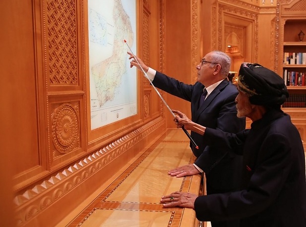
The Sultan Qaboos map
In October 2018, Netanyahu made a surprise visit to Oman to meet the ageing Sultan Qaboos bin Said, whom he praised as an “incredible leader”.
Since Israel and Oman did not have official diplomatic relations, the sight of the two leaders in official photographs was unusual. What was less unsurprising in the images, however, was the presence of a map.
![]()
![]() Inside Qaboos' opulent quarters, he and Netanyahu stood side by side, gazing at a huge map of Oman. The sultan sported the trusty pointer, while Netanyahu made do with an extended finger.
Inside Qaboos' opulent quarters, he and Netanyahu stood side by side, gazing at a huge map of Oman. The sultan sported the trusty pointer, while Netanyahu made do with an extended finger.
Not long after the trip, Netanyahu announced that Israeli airlines could now fly over Oman.
The Jordan Valley annexation map
Ahead of the 2019 elections, Netanyahu appeared on Israeli television, pointer in hand, with a map outlining the planned annexation of the Jordan Valley and northern Dead Sea.
This was, once again, a way for the politician to sell voters on his vision for Israel and the region.
While Palestinian leaders responded by saying the plan was illegal and would “bury any chance of peace”, this hardly mattered to Netanyahu, who was hard at work winning votes with his trusty pointer.
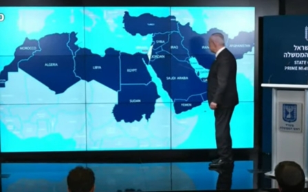
The Western Sahara map
Monday was not the first time this year that Netanyahu offended delicate Moroccan sensibilities by brandishing a map that included Western Sahara.
In May, Netanyahu made use of a map to show how isolated Israel is in the Middle East and North Africa. However, the map did not recognise Morocco’s sovereignty over Western Sahara, a territory the kingdom has claimed since 1975, following the end of Spanish colonial rule.
In 2023, Israel officially recognised Morocco’s sovereignty over Western Sahara as part of a Trump-sponsored normalisation deal between the two countries in 2020.
The map forced Israel into an apology, with a statement acknowledging an “unintended error” where Morocco “appears” to have been “cut off from its desert”.
But given Netanyahu has now shown Western Sahara twice on a map in the space of a few months - and given his love of maps - was it really a mistake?
Middle East Eye delivers independent and unrivalled coverage and analysis of the Middle East, North Africa and beyond. To learn more about republishing this content and the associated fees, please fill out this form. More about MEE can be found here.